Trail On foot Sankt Peter am Kammersberg - Greim - Photo

Tous les sentiers balisés d’Europe GUIDE+

© OpenStreetMap contributors
Length
Length
10.1 km
Max alt
Max alt
2459 m
Uphill gradient
Uphill gradient
3 m
Km-Effort
Km-Effort  
14.7 km
Min alt
Min alt
1088 m
Downhill gradient
Downhill gradient
1372 m
Boucle
Boucle
No
Signpost
Signpost
Creation date :
2022-02-16 16:49:05.855
Updated on :
2022-03-03 12:30:51.81

(0 Reviews)

On foot
On foot
3h20
Difficulty : Easy

Scan this QR Code to open this trail in the SityTrail application

FREE GPS app for hiking

Logo SityTrail SityTrail

IGN / Geographical institutes

Download SityTrail from the App Store Download SityTrail from Google Play

Logo SityTrail SityTrail World

The world is yours!

Download SityTrail from the App Store Download SityTrail from Google Play Download SityTrail on Huawei AppGallery

About

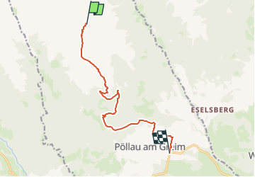
Trail On foot of 10.1 km to be discovered at Styria, Bezirk Murau, Sankt Peter am Kammersberg. This trail is proposed by SityTrail - itinéraires balisés pédestres.

Description

Trail created by ÖAV Murau.

http://wiki.openstreetmap.org/wiki/WikiProject_Austria#Wanderwege

Symbol: rot-weiss-rot 15

Elevation profile

Photos

Positioning

Country:
Austria
Region :
Styria
Department/Province :
Bezirk Murau
Municipality :
Sankt Peter am Kammersberg
Location:
Unknown
Start:(UTM)
435798 ; 5233023 (33T) N.

Trails nearby

Trail On foot Sankt Peter am Kammersberg - Greimrinne - Photo
On foot
GUIDE+

On foot

Easy
Sankt Peter am Kammersberg, Styria, Bezirk Murau, Austria
4.6 km | 15.8 km-effort
3h 36min
No


Close
My subscriptions